Jurassic Coast walks in Dorset are popular with locals and tourists alike. The Jurassic Coast runs for 95 miles between Exmouth in Devon and Studland Bay in Dorset. Known as a World Heritage site since 2001, it’s described as an area of outstanding natural beauty.
If you’ve ever visited the Jurassic Coast you’ll understand why. There is plenty to explore, with sights changing time after time due to seasons and erosion.
Before you decide on one of the Jurassic Coast walks in Dorset, it’s important to remember to check the weather and any important updates due to path obstructions. Parts of the coast path can be near the cliff edges, so do take care when walking, and stay prepared.
*This post contains affiliate links. If you make a purchase via our links, we receive a small commission at no extra cost to you*

You will also discover parts of the Jurassic Coast may be unobtainable at certain times due to the Lulworth Ranges being used for firing. Stay up to date with access times before your visit.
It’s always a good idea to have Google Maps on hand to track the instructions from these walks. Diversions can be put in place at short notice, and a physical map is a good way of keeping your bearings.
These Jurassic Coast walks are all under 5 miles in distance, some with easier accessibility than others.

Old Harry Rocks Walk
Parking: South Beach car park, Studland, BH19 3AU – (///deleting.outsiders.atomic)
Distance: 3.5 miles (circular walk)
Points of Interest: Old Harry Rocks are three rock formations at Handfast Point in the Isle of Purbeck. It marks the most eastern point of the Jurassic Coast. The rocks are named because legend says that the devil once slept on the rocks. Old Harry is an informal name for Satan.
Route:
Your walk begins from the car park, past the Bankes Arms pub to the path signposted to Old Harry Rocks. The coastal path has a small incline, keep going until you find the first gate.
From here, stay on the path towards the cliff top (keeping back from the edge). Go through the farm gate and continue along Ballard Down until you reach a stone bench marked “rest and be thankful”.
From the bench, turn right down the hill and follow the road. When you reach the crossroads, go straight on towards the church. Your walk will take you through the church yard with the church on your right hand side. There’s a right hand turn here you need to take which leads you back onto the coastal path. Stay on this path until you reach the car park again.
Things to know: This walk is an easier walk, but does get close to the cliff edge in places.

Scratch Arse Ware And Dancing Ledge Walk
Parking: Durnford Drove, Langton Matravers, Swanage, BH19 3HG (///signs.braced.tragedy)
Distance: 3.5 miles (circular)
Points of Interest: Ware is a local word which means rough grazing. Scratch Arse Ware is one of the funnier place names in Dorset.
Route:
Your walk begins in the National Trust car park at Spyway. Exit the car park through the gate and onto the path towards Spyway Barn. Take the gate to the left of the barn and continue to the far gate in the second field.
At the kissing gate, go right following the stone wall. At the next kissing gate stay along the fence until you reach Scratch Arse Ware.
When you reach the bench, your path travels diagonally down towards the sea. At the bottom, your walk joins the South West coast path towards Dancing Ledge and then onto the path signposted “upper path to Durlston”.
Read our detailed guide to Durlston Country Park to Dancing Ledge walk
The wall will be on your left as you keep walking up to the top and you reach a stile. Into the next field, the stone wall will now be on your right as you carry on walking along Priests Way.
At the fork in the path, stay right and you’ll arrive back at your starting point at the car park.
Things to know: There’s a lot of walking through fields during this walk and both inclines and descents.
Related Post – Things to do in Swanage

Heaven’s Gate To Kimmeridge Bay Walk
Parking: Quarry Car Park, Kimmeridge – BH20 5PH (///bystander.shunts.skipped)
Distance: 1.6 miles (linear)
Points of Interest: Clavell Tower or sometimes known as Clavell Folly was built in 1830. It’s a Grade II listed Tuscan style tower that was resided away from the cliff edge in 2006. Today it’s one of the many unique places to stay in Dorset, as it can be rented out through the year.
Route:
Your walk begins above Kimmeridge. As you exit the car park, follow the road and take the track on the right hand side a short way up the road. This path takes you behind the quarry and over Smedmore Hill.
You’ll pass through a gate at the end of the track, staying on the same path until you reach the end of the ridge. Here you will find “Heaven’s Gate”.
Turn around and go back the way you came until you get to the stile on your left hand side now. Go down the steep path towards the sea and over the stile into the field.
Here you need to stay on the left hand side of the field as you walk towards the sea. Turn left at the next stile and onto the South West coastal path.
Keep right now towards Rope Lake Head and Clavell’s Hard, onto Hen’s Cliff.You’ll reach the steps after Clavell Tower which lead you down to Kimmeridge Bay. Turn right past the Marine Wildlife building and up to the car park.
Enjoy the views and perhaps a picnic or some fossil hunting before making the return journey back to Quarry car park.
Things to know: There are 140 steps down from Clavell Tower to Kimmeridge Bay. Remember these will have to be climbed up as well as down to make your return journey.

Tyneham To Worbarrow Bay Walk
Parking: Tyneham Village, BH20 5DE (///avid.unstated.finds)
Distance: 1 mile linear
Points of Interest: In 1943, the villagers who lived in Tyneham village were told to move out by the British government to make way for D-Day preparations. The villagers were never able to return to their homes as the village was used for military training.
Route:
From the Tyneham Village car park, take the exit through the gate in the opposite direction to the village. The path to Worbarrow Bay is easily signposted and one continuous path.
There are toilets and a picnic area at the beginning of the walk, as well as picnic benches dotted along the route.
At Worbarrow Bay there is also a few picnic benches dotted around, or large rocks on the shingle to sit on and enjoy the view and a picnic.
Things to know: You will need to check the opening times of Tyneham Village before you travel as they can be closed due to the firing ranges.

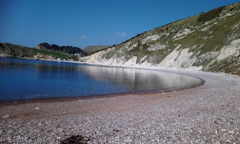
Mupe Bay To Lulworth Cove Walk
Parking: Church Road, Lulworth, BH20 5SG (///rapid.eaten.nosedive)
Distance: 4 miles (circular)
Points of Interest: Mupe Bay is one of the quieter coves along the Jurassic Coastline, possibly due to the difficulty accessing the beach. It’s one of 20 coves along the Dorset Coast.
Route:
There isn’t any easy car parking at Mupe Bay, so the best option is near the church in Lulworth. Begin your walk around Lulworth Cove and up the steps at the far end and follow the path around to the right to the lookout at the top of Lulworth Cove.
Turn right towards the army ranges and the fossil forest. There has been a diversion in place around the fossil forest in recent years due to a landslide so follow any diversions that may still be in place.
Related post – Find the best pub walks in Dorset
You’ll enjoy a nice flat walk with amazing views before your descent down to Mupe Bay. After you have enjoyed Mupe Bay, you have to tackle a steep hill. This one isn’t for the faint hearted! Walking poles are a good idea for this walk.
If the hill isn’t for you, then feel free to turn around and trace your steps back to Lulworth Cove. Onwards with the circular walk, at the top of the very steep hill walk along the ridge towards Bindon Hill.
Emerging from Bindon Hill, you’ll see you’re on the road close to the church in Lulworth and near to where you parked. Why not stop for a meal or drink in the Lulworth Cove Inn.
Things to know: This Jurassic Coast walk is only accessible when the army ranges are open.

Lulworth Cove to Durdle Door Walk
Parking: West Lulworth, Wareham BH20 5RS (///dancer.slicer.flask)
Distance: 1.5 miles (linear)
Points of Interest: Durdle Door arch is a natural limestone arch that was formed when less resilient rock was eroded by the sea.
Route:
Beginning from the large Lulworth Cove car park, take the path towards the hill at the back of the car park. This path has a gradual but quite steep incline, however there are large steps in the hill making it easier to walk on.
At the top of the hill, follow the path along the ridge until you reach the Durdle Door holiday park. Here there are refreshments and toilets if you need them.
You can’t miss the path down to Durdle Door and Man O War cove as it’s where all the people will be going! It’s definitely one of the most popular Jurassic Coast walks in Dorset.
The path down to Durdle Door is a little uneven and there are lots of loose stones and rocks so mind your footing.
You can take the steps down to the beach either side of the arch should you wish before making your return journey back to Lulworth Cove.
Things to know: There are toilets and refreshments at either end of this walk, both at Lulworth Cove and Durdle Door.

Ringstead Bay To Osmington Mills Walk
Parking: Ringstead, near Weymouth, Dorset, DT2 8NQ (///convinced.darts.bumps)
Distance: 2.2 miles (linear)
Points of Interest: Take in the views across to Weymouth as you walk along the cliff tops.
Route:
Parking in the National Trust car park at the top of Southdown Farm, your walk begins down the steep path and past the farm yard. As you pass the fields you may spot some sheep in the fields next to you.
At the bottom of the hill, you can choose to walk along the shingle Ringstead beach, or stay on the path above the beach. There are toilets and a kiosk here with refreshments.
The path comes to an abrupt stop near private houses, where you need to turn left into the forest paths. You’ll pass a small bridge and some small streams.
Follow the path out of the forest and you’ll be treated to some amazing views across the sea. There are sections of the path that get quite close to the cliff edge along this walk, so take care.
Passing Osmington Mills PGL centre on your right hand side, the path takes you across fields and out into the Smugglers Inn pub. Why not enjoy a drink or a meal before making your return journey back to Ringstead and the car park.
Things to know: Your halfway point in this walk is in the beer garden of the Smugglers Inn pub in Osmington.

West Bay To Eype Walk
Parking: Eype Beach car park – DT6 6AL (///preheated.cobras.blazed)
Distance: 3.8 miles
Points of Interest: West Bay was the location for the popular TV series Broadchurch.
Route:
Leave the car park and walk towards the beach and left onto the South West coastal path. You’ll walk around the old Forest Marble quarry and along the edge of the common. As you reach West Bay, continue along past the houses towards the quay.
At the bottom, turn left towards West Bay holiday park and walk through towards the back to reconnect with the waymarkers. The path takes you along the river through a field.
Stay on this path until you reach the road again, and cross using the underpass. Take the second path you see through a gate next to a cottage and follow the path until you reach Skilling Hill road.
Turning left you’ll pass a school and sports pitches before crossing the bridge towards Highlands End holiday park.
The footpath you need is on the left up some steps in the bank. This follows the road to Eype, where you turn right onto Mount Lane and back to the car park.
Things to know: West Bay was originally known as Bridport Harbour at the mouth of the river Brit.